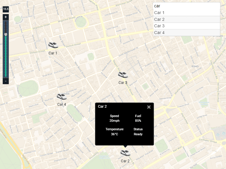
The Vehicle Tracking Map widget uses the Maptalks API and displays a street map of the world and you can add markers/vehicles via folders you have setup in the station. Geo-coodinates lat/long points in each folder update and move the markers in real-time to their location. At different zoom levels, when markers are too close together, they automatically cluster together and show the number of markers in that area. Unlike our other open maps widget, this widget allows you to set up to 4 point values derived from each station folder. The values are shown on a tooltip via single click, which is great for mobile users as well. Tooltip icons can also be changed to a image of your choice, or removed entirely. Values and markers also update in real-time. A search box will also help find markers and automatically pan to them when clicked. You need an internet connection to view the maps. The widget has a number of configurable properties that can be used to modify look, feel, and functionality. NOTE: the service that updates the lat/long of the point automatically is not part of this widget and must be done by yourself. You could consider using some mobile app, sms, or rest api to update the Geo Location point. We may consider adding something in the near future, but it is currently not part of this solution.
Are you looking for a cost effective way to manage and visualize data for all your customers? Why not have a look at View Builder ?
Before you start. Download the modules from our portal (see your order confirmation, which also explains licensing). Copy the modules file to your modules directory. Restart BOTH station and Workbench.
1. Copy the vehicleTrackingMap-ux.jar file to your modules directory. 2. Open the module from your palette file. 3. Drag and drop the widget from the palette onto your px view. Note: in 4.10 you will need to modify the Web Service settings in the station to allow maps to show up See Here frame-src * img-src 'self' workbench data: https://a.basemaps.cartocdn.com/ https://b.basemaps.cartocdn.com/ https://c.basemaps.cartocdn.com/ https://d.basemaps.cartocdn.com/ https://www.wse-ltd.com https://cdn.jsdelivr.net style-src 'self' workbench 'unsafe-inline' https://fonts.googleapis.com https://cdn.jsdelivr.net script-src 'self' workbench 'unsafe-inline' 'unsafe-eval' https://fonts.googleapis.com https://cdn.jsdelivr.net
System Folder Config
This should point to a folder which contains a set of sub-folders representing markers. Example: station:|slot:/Drivers/VehicleTracker
The folders display name is what represents the marker on the map. All points and folders will get picked up automatically by the widget.
Each folder should have the above 5 points in their respective folder.
The widget has a number of configurable properties that can be used to modify look, feel, and functionality. Change the properties as required:
The current version when writing this document is 0.49.5. As we do not maintain the mapping images, change this value as new versions are released. The latest version value can be found here. https://github.com/maptalks/maptalks.js/releases
The map will display at this location when initialised.
The viewing angle of the map.
Overview Control, Scale Control, Zoom Control
Shows/hides the controls on the map. Set to true or false.
The default zoom level. Default is 15.5.
Possible values light or dark.
Set these values to manually set the height/width of the map frame.
Use a custom marker image file. File must exist in stations shared directory. Also set useMarkerImage property to true.
Base Maps Url - Style
There are a few different styles you can display. Default: https://{s}.basemaps.cartocdn.com/rastertiles/voyager_labels_under/{z}/{x}/{y}.png No Labels: https://{s}.basemaps.cartocdn.com/rastertiles/voyager_nolabels/{z}/{x}/{y}.png Positron w/ Labels: https://{s}.basemaps.cartocdn.com/rastertiles/light_all/{z}/{x}/{y}.png Positron without labels: https://{s}.basemaps.cartocdn.com/rastertiles/light_nolabels/{z}/{x}/{y}.png Dark with Labels: https://{s}.basemaps.cartocdn.com/rastertiles/dark_all/{z}/{x}/{y}.png Dark without labels: https://{s}.basemaps.cartocdn.com/rastertiles/dark_nolabels/{z}/{x}/{y}.png
The Marker GeoLocation updater service is not included in this widget. If you want to test the markers moving create a program object with the code below. Modify as required.
When updating your GeoLocation point it should be a comma separated string e.g. -0.14841,51.51452. (longitude/latitude)
back to more widgets...
Build Your Own dashboards and win Projects by showing data that increase value and reduces expenditure.
Home About Us Current Projects Affiliations Privacy Policy ECommerce Policy
View Builder IOT ™© Mobile Solutions N4 View Builder ™© Niagara PX Graphics
Software Development Consultancy Project Management Graphic Design Knowledge
T: +44 (0)800 511 8446 (UK) +1 888 207 4061 (US)
Copyright © 2025 Works Software & Engineering Ltd. All rights reserved.